Thursday, August 23, 2007

PAC led 1960 Poisitve Action Campaign Route from Orlando East

Date: 17 July 2007
Route Guide: John Gaanakgomo (PAC member)
Documenter: Ismail Farouk
Facilitator: Ali Hlongwane, (curator HPMM)
Observers: John Mahapa and Babak Fakhamzadeh

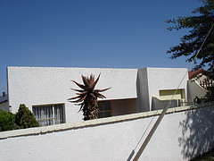
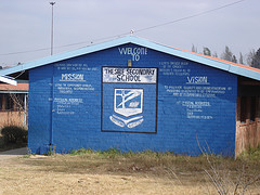
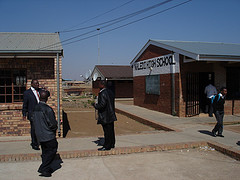
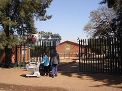
John Gaanakgomo was the first Chairman of the PAC in Orlando East. His political career began in the ANC Youth league but because of ideological differences with the organisation, he along with other members of similar thought, broke away from the ANC to form the PAC. Gaanakgomo elaborates, " We deviated from the ANC because of the issues around land and Africaness. The Freedom Charter states, “The People Shall Govern”. But who are the People? Africa is for Africans!" It was because of the contrary issue of Africanism that the PAC was formed at the Orland East Community Center in 1959.

2 johns

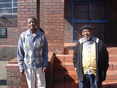
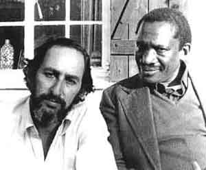
Figure:
John Mahapa (left) and John Gaanakgoro standing outside the Orlando East Community Center

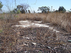
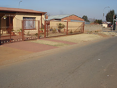
On the morning of 21 March 1960. Members of the PAC were strategically positioned on street corners in Orlando East to intercept men walking to the train station on they way to work. Passing men were encouraged not to go to work but rather to hand themselves over for arrest.

John Gaanakgomo's Position

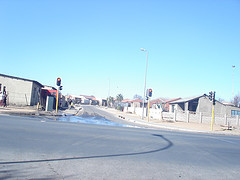
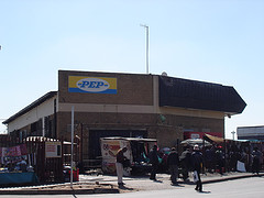
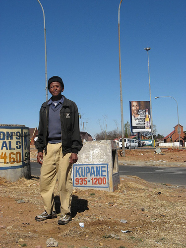
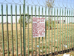
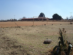
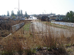
Figure:
John Gaanakgomo waited here on the 21st March 1960. He targeted all males on their way to work asking them to present themselves for arrest at the police station.

Gaanakgomo was positioned near Mlamlankunzi Station which is located in close proximately to the Orlando Police Station. He remembers addressing men asking them to proceed to the Police Station. He received mixed reactions to his request, "Some men were surprised, others thought we were mad for our actions. Some joined willingly. Others were forced to."

As the PAC members walked towards the police station on Mooki Street they sang their songs and were greeted by students from Orlando High School. Some students joined the march.
The idea was to flood the jails as a protest action against reference books.

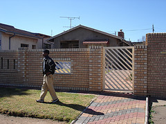
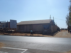
As they neared the police station, the men were warned about special police who were deployed to disrupt the march. So the marching men dispersed and took back roads to avoid special police. Soon they reached the Orlando Police Station where the waiting men assembled under the shade of a blue gum tree.

orlando police station

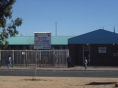
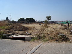
Figure:
Outside the Orlando Police Station

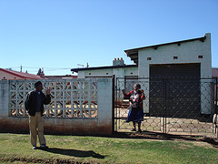
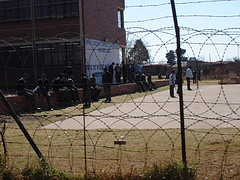
Gaanakgomo remembers waiting outside for most of the day. More men arrived in drips and drabs. Eventually, the police arrested the core members of the organization only. But Gaanakgomo and his group insisted on being arrested with their leaders and so a short while later all of the waiting men were arrested. John Gaanakgomo was detained for several months later.

Labels: , , , ,

Tuesday, August 21, 2007

PAC led 1960 Poisitve Action Campaign Route from Dube

Date: 08 August 2006
Route Guide: Raselepe Nthaledi (PAC member)
Documenter: Ismail Farouk
Facilitator: Ali Hlongwane, (curator HPMM)

On the 8th August 2006, Raselepe Nthaledi, Ali Hlongwane, and I retraced the 1960 Positive Action Campaign route through Soweto from Nthaledi’s house in Dube Soweto. Nthaledi was called upon early on March 21, 1960 by his comrade and then treasurer of the PAC, Jerry Leeuw, who lived down the road on the corner of Wycliff and Butshingi Streets.

Jerry Leeu's House

Figure: Jerry Leeuw’s home on the corner of Wycliff and Butshingi Streets.

Together, Leeuw and Raselepe walked up Tshabangu Street, turned left into Modiba Street and then right into Chalker Street and immediately right again into Merapelo Street. A little further on, they made a small detour to collect an old man who lived on Thabo Street. The old man was not feeling well and did not want to march so the two men continued to collect Mr. Nkula who lived closed by on Tsekedi Street before heading up the road to wait for other groups to arrive at Maponya Stores.

Maponya Stores

Figure 57: The bus stop near Maponya Stores where PAC members waited on route to Orlando Police Station.

Mr Nthaledi’s group joined other groups outside Maponya Stores and continued further on Pela Street past the HPMM on their way down towards the Klipspruit River. They crossed over and turned left into Mooki Street and walked up to the end point of the march at Orlando Police Station. A little while later he was arrested and detained for incitement.

Labels: , , ,

PAC Led Positive Action Campaign Route from Mofolo

Date: 08 August 2006
Route Guide: John Mahapa (PAC member)
Facilitator: Ali Hlongwane (Curator HPMM)
Documenter: Ismail Farouk
Observer: Milos Sajin

John Mahapa is a member of the PAC. On the 21 March 1960, Mahapa began his march against the pass laws of the Union of South Africa. His march started outside the house of the general secretary of the PAC, Potlako K. Leballo in Mofolo and ended at the Orlando Police Station where he asked to be arrested for failing to carry a pass book.

Mahapa explained, “Congress of December 1959 resolved a date for an anti-pass campaign to begin in February 1960. On the 21 March all African males who were pass carrying needed to leave their passes at home and surrender themselves to the nearest police Station”. This action was taken in order to bring the economy to a standstill as the labour force would be behind bars.

On the 8th of August 2006, John Mahapa, Ali Hlongwane, Milos Sajin and I retraced Mahapa’s route through Soweto. The beginning point for our route was the former home of the PAC Secretary General, Mr. P.K. Leballo near Mofolo Park. Forty-six years later, the landscape of Soweto has changed much. Most houses have been upgraded and don’t bear any resemblance to the original township houses. These factors made the identification of P.K. Leballo’s house somewhat difficult but we eventually found the house, number 1144 on Nhlapo Street. This is where the Mofolo group started early on March 21, 1960.

Looking for the House

Figure : John Mahapa looking for P.K Leballo's house


John Mahapa outside PK Leballo's House

Figure: John Mahapa with current resident of house number 1144 Nhlapo Street Mofolo, the former house of the PAC Secretary General Mr. P.K. Leballo

According to Mahapa, a group of twenty people started outside 1144 Nhalpo Street in Mofolo. The group began their march at 06h00am. They marched up Mncube Street. At the corner, near Maponya Stores, they joined another group from Dube before proceeding down Mahalafele Street and then down Kumalo Street, across the Klipspruit River before turning left into Mooki Street where they waited under the shade of a bluegum tree outside the Orlando Police Station.

John Mahapa PAC

Figure: John Mahapa standing across the Orlando Police Station. Forty-six years ago, this is where PAC members waited to be arrested, under the shade of a bluegum tree.

blue gum tree 1960

Figure: John Mahapa shares a picture of the (uprooted) blue gum tree

PAC members waited all morning to be arrested and soon became hungry. By lunch time group thinned out to eat and according to Mahapa, this is when 72 members were arrested. When the remaining group returned, the police station gates were closed. Mahapa jokingly related how he planned to go to the movies later that afternoon failing detention. He wanted to watch the classic movie, Bridge on The River Kwai, starring William Holden. Mahapa was arrested, however, and was taken to magistrate court and punished with 10 lashes instead.

Labels: , , ,

Robert Sobukwe and the PAC Positive Action Campaign against the Pass Laws Act of 1952.

Figure: Benjamin Pogrund & Robert Sobukwe (http://www.wits.ac.za/histp/sobukwe.htm)

On March 18th 1960, Robert Mangaliso Sobukwe, the leader of the PAC announced at a press conference that the PAC would launch the first phase of its ‘programme’ for the liberation of South Africa on Monday, March 21, 1960. The target of this campaign would be the pass laws. A door-to-door campaign was reinforced with a call on all pass-carrying African men to leave their passes at home, march to the police stations nearest them and demand to be arrested for refusing to carry a pass (www.wits.ac.za/histp/sobukwe_bio.htm).

In the build-up to 21 March, the PAC President, wrote to the Police Commissioner in Cape Town asking him to instruct his men not to allow themselves to be provoked into violence:

“Sir: My organization, the Pan-African Congress, will be starting a sustained, disciplined, non-violent campaign against the pass laws on Monday, 21 March 1960. I have given strict instructions, not only to members of my organization but to the African people in general, that they should not allow themselves to be provoked into violent action by anyone. It is unfortunately true that many white policemen, brought up in the racist hothouse of South Africa, regard themselves as champions of white supremacy, and not as law officers. In the African they see the enemy, a threat, not to “law and order” but to their privileges as whites.

I, therefore, appeal to you to instruct your men not to give impossible demands to my people…”

- Extract from Robert Sobukwe’s letter to SAP, Major-General C.I. Rademeyer (Pogrund 1990:123).

Early in the morning of Monday, 21 March 1960, Robert Sobukwe left his house with six of his colleagues. They walked down the street towards the main tarred road. Here, they turned right towards the grocery store owned by Tshabalala. They were met by 10 – 15 men and after a while the group set off up the hill towards Dube Station and turned right to head for Orlando Police Station about 4.5 km away. An hour later, they reached the police station. There were scores of protestors already at the police station when Sobukwe’s group got there. (Pogrund 1990)

By 08h20am, Sobukwe, Leballo and others walked through the gates of Orlando Police station and requested to be arrested for not carrying any passes. In the charge office Captain J.J de Wet Steyn was a bit annoyed at being disturbed and asked Sobukwe and the others to wait outside the police station. He later came outside and warned the crowd not to make a noise or he would “take steps” (Pogrund 1990:131).

And so the PAC men spent the first half of the morning waiting across the road under the shade of a bluegum tree. It was during this period that Sobukwe learnt that police had opened fire at Bophelong and he was visibly upset. Pogrund, decided to drive to Vereeniging to see what was happening. (Pogrund 1990)

By 11:20am a policeman came outside and called out the names of the PAC leadership. Sobukwe, Leballo and the other core members were placed under arrest for ‘incitement’. The police asked the remaining members to leave, but the PAC members insisted that they wanted to be with their leaders, so the police arrested the remaining group.

Later that afternoon police opened fire on people in Sharpville. The precise number of deaths is uncertain, and has been variously stated as 67, 69 or 71 (Pogrund 1990). 186 people were injured, 40 women and 8 children. 75% of victims were shot in the back whilst three policemen were slightly injured by stones. (Pogrund 1990)

During the day, information of the Sharpville massacre reached Sobukwe. He was extremely disturbed by the news but urged his comrades to remain calm. Sobukwe and his colleagues were sentenced to three years under 'incitement laws', but before his term of imprisonment ended on Robben Island, the government introduced an amendment to the law enabling them to keep Sobukwe and others in indefinite detention. (http://www.wits.ac.za/histp/sobukwe_bio.htm)

Sources:

1. Historical Papers, Wits University, http://www.wits.ac.za/histp/sobukwe.htm
2. Pogrund, P. (1990): How Can Man Die Better: The Life of Robert Sobukwe, Houghton Mifflin, South Africa.

Labels: , , ,

Sunday, August 19, 2007

Process: Madibane High School

Date: 08 August 2006
Route Guide: Ali Hlongwane (Curator HPMM)
Documenter: Ismail Farouk

On the 8th of August 2006, Ali Hlongwane and I set off to retrace the route taken by students from Madibane High School in Diepkloof. The street layout of Diepkloof differs from the rest of Soweto. Most roads form crescents and there is an absence of street name signage. As mentioned before most major roads are named ‘Immink’, which adds to the confusion when trying to navigate the suburb.

Madibane High School Start

Figure: Madibane High School Route Starting Point

After much difficulty, Ali and I located the spot on the eastern boundary of the school on Ramosi Street, where the small gate exit was located in 1976. Today the small gate is no longer in use and the school has been fenced off. This is where students began their march on June 16 1976 from Madibane high School. Ramosi Street forms a crescent and we followed the road in a northerly direction and then in an easterly direction before coming to a T-junction.

We turned left into Patrick Street and right into the major Immink Road and proceeded south towards the intersection of Immink Road and Eben Cuyler Street. We crossed the intersection and stopped outside the sports grounds to our left. This is where students from Madibane High School joined the group from Junior Secondary School. Their intention was to march to Orlando stadium but news of the killing of Hector Pieterson filtered through and the intended march did not take place. Instead students became angry and set off on a rampage destroying all government administration buildings.

Diepkloof Sports Grounds

Figure: The meeting spot - Diepkloof Sports Grounds

One of the buildings which was targeted was a WRAB beer hall which was located on the intersection of Eben Cuyler Street and Immink Road. The beer hall was looted and gutted by students on June 16. The looting was followed by drinking and partying, signaling that the next few days were destined to be spent at home.


WRAB Beer Hall Diepkloof

Figure: The WRAB Beer Hall Site - Diepkloof

A bit further down Eben Cuyler Street, Ali pointed out the “Blackjacks” offices. “Blackjacks” were police who enforced influx control. Today, the offices have been reduced to rubble. New social facilities are being developed on the site.

Blackjacks Influx Control - Remainig Rubble

Figure: Rubble from the original Blackjacks offices

Diepkloof remained as one of most active townships in 1976 where running battles between police and students continued for some time later. For the rest of the year, all schools were closed, with no further learning taking place.


Labels: , , ,

Process: Junior Secondary School Route

Date: 10 August 2006
Route Guide: Ali Hlongwane (Curator HPMM)
Documenter: Ismail Farouk

On the 10th of August 2006, Ali Hlongwane and I set off to retrace the Junior Secondary School route in Diepkloof. Junior Secondary School has been renamed to Bopasenatla High School and is located on Sono Street in Diepkloof. Sono Street exists on an east-west axis and was difficult to identify, mainly because of the absence street signs. Ali spent his childhood years in Diepkloof and has an intimate knowledge of the many passageways and unnamed roads which characterise the area. His knowledge and memory of the area was invaluable as we struggled to find appropriate street names. Our map of the Diepkloof area was highly inaccurate and still bears coded reference numbers as street names. To add to our confusion, Diepkloof has many streets and roads with the same name. Most roads are called ‘Immink’.

Junior Secondary School
Figure: Junior Secondary School

After documenting the current schoolyard, Ali pointed out an adjacent vacant lot which was the site of WRAB offices in 1976. The WRAB offices were destroyed in the aftermath of Hector Pieterson’s killing. The land has remained undeveloped ever since.

We began by crossing Sono Street and walked in a northerly direction towards Mbila Street which forms a crescent. At the northern end of Mbila Street we proceeded through a pedestrian passageway which connects with Dlanga Street which also happens to form a crescent. We continued on our northerly trajectory through a second pedestrian passageway. The environmental conditions through both the passageways were very poor. The area was characterised by illegal dumping along the edges.

Diepkloof Passageway
Figure: The first passageway

At the northern end of the second passageway, we stopped near a dusty soccer field. From here we could clearly see Vulazamazibuko Higher Primary School just ahead. This is where Ali went to School in 1976. He commented on how he still remembers seeing large crowds of students emerging from the passageway which we had just walked through on their way to meet students from Madibane High School. This is where Ali joined the march.

Dusty Football
Figure: Dusty Football Field

On the northern boundary of Vulamazibuko Higher Primary School, on Tsekuhle Street, Ali pointed out the house of the Zulu shaman, Credo Mutwa. Credo Mutwa’s house was destroyed during the uprisings for comments he made regarding the negative nature of the uprisings. After a brief pause, we continued north on Immink Street. We stopped at the intersection of Immink and Eteza Streets, where Ali pointed out his childhood home to me.

Ali Childhood Home
Figure: Ali Hlongwane's Childhood Home

Ali commented on how drastically the environment has changed over thirty years. Further down Eteza Street, new larger residences have been built. One such residence, on the corner of Eteza and Umhanga Streets was a former WRAB office which was also attacked and destroyed during the uprisings. At the end of Eteza Street we paused and looked at the park and offices ahead. The offices ahead were WRAB administration buildings which were burnt and destroyed. Today, the former WRAB site is home to municipal rental offices. The park which surrounds the municipal offices exists in a poor, overgrown state. Ali commented that the park has been recently upgraded but a lack of management has led to its current poor condition.

Overgrown Park Diepkloof
Figure: Overgrown Park Diepkloof

We turned right up Immink Road and continued in a Northerly direction on our final part of our journey towards the sports grounds near Eben Cuyler Street. Here students joined the group from Madibane High School but instead of marching to Orlando Stadium as intended, news of Hector Pieterson’s death filtered through the ranks and the intended peaceful march turned to anger as students attacked buildings associated with the apartheid regime.

Labels: , , , ,

The Uprisings in Diepkloof

Steve Lebelo was a student from Madibane High School in Diepkloof. His life and future in the liberation struggle was shaped by the killing of his older brother Abe Lebelo who was killed on the 4th of August 1976. Following his death, Steve Lebelo decided to take on the liberation struggle as a personal goal (Brink and Malungane 2001).

According to Lebelo, Diepkloof is steeped in the history of resistance going back to the 1940s and 50s, long before the location was established. The community resettled in Diepkloof in the second half of 50s and early 60s came from a tradition of resistance to Apartheid. The first group of families resettled in Diepkloof was drawn from the legendary Sophiatown, the freehold township held up as a model of resistance to white rule in South Africa (Lebelo 2006).

Lebelo’s testimony claims that Diepkloof was as prepared for the revolt as were Naledi, White City and Orlando West. Madibane High School in Diepkloof was represented in the meeting that decided on the march and established the Soweto Students’ Representative Council (SSRC). At Madibane High School students were notified of the march as early 14th June 1976.

"From the morning assembly on 16 June 1976, Madibane High School students did not march into their classrooms. Instead, they headed to the centre of the township, having been joined by students from nearby Namedi Junior Secondary School. Both groups of students marched along Immink Drive towards the Diepkloof Sports Grounds. Here they were scheduled to meet with students from Bopa Senatla Junior Secondary School, and together march down Masopha Street towards Orlando Stadium .

By the time the marching students reached the sports ground area, they had been joined by hundreds in the township. News of developments in Orlando West reached Diepkloof even before students could start the march down Masopha Street to Orlando Stadium. Because Diepkloof had Council police headquarters located next to the sports ground where students converged, they responded quickly to the threat, dismissing students with teargas.

As the crowds scattered, mayhem followed. Students and unemployed youth returned and started attacking the nearby beer hall. The beer hall was gutted by fire within an hour and crowds from the township looted it. The next building to be attacked was the Council Offices in Zone 1, but by the time the students reached the offices, all white personnel had been evacuated. This followed the murder of Dr. Edelstein in White City earlier in the morning. By midday, students and unemployed youth were making their way home with large quantities of liquor looted from the beer hall. What followed was drinking and festivities, signaling that the next few days were destined to be spent at home."

Extract from submission by Steve Lebelo (2006).

Labels: , , ,

Thursday, August 16, 2007

Process: Tshesele High School Route

Date: 03 August 2006
Route Guide: Antonette Sithole (June 16 Foundation)
Documenter: Ismail Farouk and S'phelele Nxumalo (ASM)
Observer: Oupa Moloto (June 16 Foundation)

On Thursday 3rd August 2006, Our research group began to map the route taken by Antonette Sithole on June 16 1976 from Tshesele High School in Central Western Jabavu to Phefeni Junior Secondary in Orlando West. Sithole is Hector Pieterson's older sister. Today she works for the June 16 Foundation which is located within the Hector Pieterson Museum.

Thesele High School
Figure: Tshesele High School

At the beginning point, within the Tshesele school grounds, Sithole described how students from the nearby Morris Isaacson High School came to her school to collect students in their united march against the oppressive system. Sithole said, “We were very happy with pride, we were looking forward to uniting with other schools. It was the first time that students were without parents and so very happy. No one told us what to do and we were happy to miss school. Singing and chanting…we were told to be calm and not to provoke the police…We planned to walk on the main street but took short cuts to avoid police”.

We left the school grounds and walked in a northerly direction on Diokane Street. I asked Sithole how her brother Hector got involved in the march, to which she replied, “The younger one's saw us leaving in our uniforms and wanted to join the excitement".

We turned right off Diokane Street, into Mavi Street and left into Mlangeni Street and proceeded west towards Mputhi Street. At this point, Tshesele High students joined the main group from Morris Isaacson High School. Today a general dealer called Sizwe Stores is located at this meeting point. In 1976, there was a coal yard on the site. Oupa Moloto commented that there were about 2000 students in the group outside the coal yard.

From this point, Sithole directed us north on Mputhi Street past the Mshenguville Squatter camp. We soon turned right onto Mwasi Street and proceeded through Mofolo Park on Mzilkatzi Street.

Trolley Pusher Mofolo


Figure: Trolley Pusher on Mzilkatzi Street.

We turned right into Mptipa Street and stopped outside the home of Dr. Nthato Motlana. Dr. Motlana devoted his live to serving the community of Soweto. He was the founder of the Black Medical Discussion Group in the late sixties to raise funds for struggling medical students and was involved in many other community organisations (Mashabela 1987). It was here outside the home of Dr. Motlana where Tsietsie Mashinini addressed students warning them about a police presence and calling for calm.

I asked Moloto how Tsietsie got to this point as he had just addressed another group of students at the landmark bridge on Machaba Street. Moloto explained that unmarked vehicles were used by the coordinators of the march on the day. He suggested that the vehicles were hired by members of the ANC. Tsietsie was driven around and was therefore able to address various groupings of students at various stages of the march.

The route meandered along Mtipa Street and we soon turned uphill on Butshingi Street. At the top of Butshingi we turned right into Vilikazi Street. Further on Vilikazi Street we stopped at the official shooting site of Hector Pieterson on the corner of Vilikazi and Moema Streets. The memorial is often vandalised by youth who express themselves through graffiti.

They Will Pay
Figure: The Memorialised Shooting Site

According to Sithole, the location of the official shooting site differs from the actual spot where her brother was shot. She remembers the shooting site being closer to the corner of Moema and Phiri Streets where she was hiding in the yard of the corner house.

Antonette Sithole
Figure: Antonette Sithole relives the events of June 16 1976.

I asked Sithole what happened here once she got here? Sithole relates: "When the shooting began, I went into hiding. When the shooting stopped, I came out of hiding when others came out. I saw Hector across the street, and I called him and waved at him, he came over and I spoke to him but more shots rang out and I went into hiding again. I thought he followed me but he did not come. I came out of hiding and waited at the spot where I just saw him but he did not come. When Mbuyiso came passed me a group of children were gathering nearby. He walked towards the group and picked up a body...And then I saw Hector's shoes".

Famous Photo Site
Figure: The Famous Photo Site

A short time later Sithole was running beside Mbuyiso who was carrying Hector Pieterson. They headed towards Phomolong Clinic along Sisulu Street. Along the way, a photographer called Sam Nzima took the famous picture of the distressed children.

Whilst at the clinic Sithole watched a frenzied mob kill a white municipal worker who was later identified as J.N.B. Estherhuizen. He was dragged from his car and brutally killed. Estherhuizen was one of two white officials killed on the day.

phomolong cliinic
Figure: Phomolong Clinic

Hector Pieterson was pronounced dead here at Phomolong Clinic. Today, Sithole continues to keep her brother's memory alive with her work at the museum and as a public speaker. When not in the museum, she can be found on the streets of Soweto, physically laying the bricks on the the route taken by students on June 16 1976.


Labels: , , ,

Process: Mapping The Naledi High School Route

Date: 22 August 2006
Route Guide: Patrick Lephunya, Regional Director of Soweto
Facilitator: Ali Hlongwane (Curator HPMM)
Documenter: Ismail Farouk
Observers: Oupa Molota (June 16 Foundation),
Angel David Nieves, PHD. (Director Graduate Research & Training, Consortium on Race, Gender, and Ethnicity at Maryland University)

On the 22nd of August 2006, our research team retraced the Naledi High School Route under the direction of Patrick Lephunya, the regional director of Soweto.We began our journey at the school where Lephunya described the events of the morning of June 16, “At assembly the principal NJK Molope came in and wanted to sing a hymn but students stood up and shouted out, ‘Amandla!’ and sang ‘Nkosi Sikelele Afrika’ instead. The students unfurled banners and plackards before heading off into the streets”.

Naledi High School
Figure: Patrick Lephunya (left) describes the morning's events at Naledi High School

Lephunya showed us the telephone lines outside the principal’s office which were cut in order to prohibit any calls to the police. Earlier, on the 9th June, two policeman came onto the school grounds to arrest a student. The student in question, Enos Ngutshane was wanted for questioning.
The principal came into our classroom and said, ‘hey, mmona (man) it looks like you are in trouble the police are here and they would like to go with you’. Then he went back to his office and continued the discussion with the police just to find out what is happening, “I took my bag instead of going to the principal’s office I went to the classrooms where the members of the South African Student Movement (SASM) were and said, ‘guys I’m in trouble the police are here to arrest me’. So there was a quick discussion and the guys said, ‘you know what don’t go to the office, you go back to your classroom and give us 10 minutes [Laughs]’. So I was looking at my watch exactly 10 minutes the bell went. But it was not natural; it wasn’t supposed to be ringing at that time. But they had done their work. They had already moved into all the classrooms to say the bell is going to ring and all of us must be at the assembly. So we went to the assembly and students were in one voice ‘you are not going anywhere’.
Later, Ngutshane walked in the principal’s office and said ‘this is the situation it looks like nobody is going to leave the school, including myself [Laughs]’. So there was pandemonium in the principal’s office. As the three of us were still talking, the white policeman, the principal and myself, the other police guy came in and said, ‘hey, the car is now on fire outside [Laughs].
The police car was destroyed, burnt and overturned. Unfortunately the students did not cut the telephone line on time and police reinforcements soon arrived.

(Extract from an interview with Enos Ngutshane)


After, a brief inspection of the school grounds, and the memorial to those who lost their lives in a bus tragedy in Mozambique in 1974, our group set off in a hired mini bus.

Contrary to popular belief, the Naledi High School Route does not make a beeline to Morris Isaacson School as illustrated by the proposed paving route on the Johannesburg Roads Agency map., The Naledi route remains highly contested. However, the initial stages of the route shown to us by Lephunya, is corroborated by Harry Mashabela in his book, “A People on the Boil”. The book contains a very detailed description of the initial stages of the Naledi High School Route.

Batswana High School
Figure: Batswana High School

Our first destination was Batswana Junior Secondary School, which is located close to Naledi High School in a South Eastern direction. Today, Batswana Junior Secondary School is known as Thabo Secondary School. Lephunya described how students from the school gathered at the small gate as they waited for the Naledi group to arrive before heading off to Thomas Mofolo High School.

Thomas Mofolo High School
Figure: Thomas Mofolo High School

At Thomas Mofolo Senior Secondary School, a further 500 students waited to merge with the Naledi group. Our journey continued down Mpetslane Street where Lephunya pointed his mother’s house out. On the morning of the march Lephunya stopped here to drop his school books off before continuing with the march. He also added that there were no incidents at this point of the march.

Tdladi Secondary School
Figure: Tladi Secondary School

Lephunya directed the minibus right and then left onto Legwale Street before turning left onto Thamagane Street where more students from Tladi Secondary School joined the march. We meandered through tiny unnamed residential streets, and a few sharp turns later we found ourselves back on the main road, Masiane Street. Our next stop was Moletsane High School where students asked us to photograph them in front of the school. We continued on Masiane Street and turned right into Mphahlele Street where we stopped outside Mphahlele High School.

Moletsane High School
Figure: Moletsane High School

The next part of the route is where the greatest contestation lies. The plan on the day was to merge with students from Morris Isaacson High School and this is supported by Harry Mashabela’s book, which describes the scene when the Naledi group arrived at Morris Isaacson High School to find the school deserted with a sign at the gate which read, “No SB’s – Trespassers Beware!”. Lephunya’s route, however, does not include Morris Isaacson High School, rather it meanders through the ‘big circle’, at Letabe Street in Central Western Jabavu, east of Morris Isaacson High.

An explanation for the contestation can be found in the fact that not all students followed the same path. While the majority of students may have taken the path described by Lephunya, it is possible that some students from Naledi walked along Makapan Street before turning right into Mputhi Street towards Morris Isaacson High School. This possibility can be explained by the testimony of Solly Mpshe in the book “June 16 1976” by Brink and Malungane (2001). Mpshe was a student at Morris Isaacson High School. He relates being forced out of his class and being forced to march despite not knowing what was going on. He says that this occurred during the second period around 09.30am and places responsibility for being forced into marching on students from Naledi High School (Brink and Malungane 2001:39).

Lephunya’s route continued on Letabe Street in a northerly direction until the street changes name to the Moroko Nancefield Road. We turned left into Mncube Street and continued westwards towards Mahalefele Street. We turned right on Mahalefele Street but instead of turning towards Vilikazi Street, the end point for many other school routes, we continued down towards the Klipspruit River close to the point where Hastings Ndlovu was killed.

Hastings Ndlovu Shooting Site
Figure: Hastings Ndlovu Shooting Site

We stopped just before the bridge on Kumalo Street. On the other side of the bridge is where police were reported to have congregated. Lephunya’s version of the Naledi High School route ends here.

Sources:

1. Brink, E. and Malungane, G. (2001): Soweto 16 June 1976, Personal accounts of the Uprisings, Kwela Books, Cape Town.
2. Mashabela, H. (1987): A People on the Boil, Reflections on Soweto, Skotaville, Publishers, Johannesburg and Cape Town.


Labels: , ,