Thursday, July 03, 2008

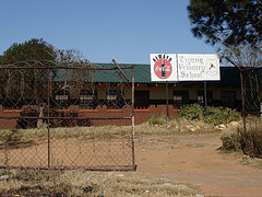
Tiyang Primary School: Meadowlands

Maki Lekaba was a standard five student at Tiyang Primary School. On Wednesday June 16 1976, Maki went to school not knowing that anything out of the ordinary was being planned.

Tiyang Primary School

She was surprised when addressed by high school pupils from nearby Meadwolands High School at the school gates. The older pupils were attempting to recruit younger pupils in the march against oppression. Maki had no idea that Afrikaans was being used as an instrument of oppression by the apartheid government. She joined the march against Afrikaans as a medium of instruction, in solidarity with other school pupils.

Maki followed the older pupils through Meadowlands. Along the way she witnessed the destruction of offices and liquor outlets related to the West Rand Administration Board (WRAB).

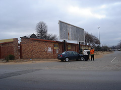
WRAB Offices Destroyed on June 16 1976

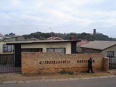
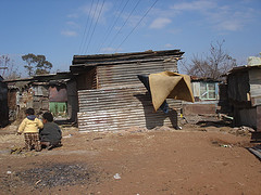
The house above is the former site of a WRAB rental office. On June 16 1976, this WRAB office was set alight and destroyed along with all its records and documentation. The students continued on a path of destruction, robbing a furniture truck and bread delivery truck before destroying a bar associated with the apartheid regime.

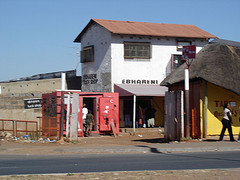
ebhareni

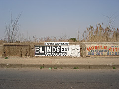
The two-storey structure pictured above is a former WRAB Beer Hall (Bareng). The destruction of this beer hall was the final act of destruction by students from Meadowlands. Students were forced to scatter into nearby homes as police converged into the area.

This is where Maki's march ended. She returned to her home and was glad not be in school for the next few days.


Here is a short audio interview with Maki Lekaba:


Labels: ,

Monday, June 30, 2008

We are loved

Chad Rossouw over at A R T T H R O B wrote up a nice article on this very website recently.

This seamless technological approach takes a back-seat though, to the well researched content. Farouk, who was the chief researcher, explored the routes with guides who told him the stories. Points of interest were photographed. On the map these photos and stories can be accessed by clicking on the spots. The contemporary photos provide an entry point both to the past events as well as urban history since. The result is an in-depth look at a significant historical moment, but which is easily understood and reached.
Clearly, we're doing something right!

Labels: , , ,

Thursday, December 06, 2007

Research Findings

Phase 2 of the Hector Pieterson Research Project ended in September 2007. Here is a list of research findings and constraints:

  • There are number of meeting places and social networks which provided support to the students during the planning stages of the uprisings. The house of Mr. Mbatha and Titi Mthenjana stand out in particular. Oupa Moloto is certain of the existance of further landmarks in White City, however he is struggling to remember where they are.
  • Naledi demontrates a rich political history, which this research process has only touched on. There are a number of homes belonging to student leaders which still need to be located.
  • The history of the conflicts between hostel dwellers and township residents presents an important perspective social dynamics within Soweto. The geographic proximately of Jabulani Hostels to the newly developed 1976 Heroes Acre presents an opportunity to communicate this historically important relationship to new visitors.
  • There are a number of Important landmarks pertinent to Hector Pieterson’s childhood life which need to be identified. Hector’s creche, the local shop, Hector’s School and the swimming pool in Central Western Jabavu are all important landmarks in the historical landscape of 1976.
  • Diepkloof also has a rich history that has rarely received attention. According to Steve Lebelo, Diepkloof offers an ideal terrain to examine how forms of extended social networks developing since mass resettlement of communities in the 1950s and strengthened by the unifying ideology of Black Consciousness during the 1970s, broke down in the face of new political identities.
  • Research into the life of Mbuyiso Makhoba needs to be prioritised. Not much is known about this important person who was immortalised in Sam Nzima’s famous photograph.
  • A small group of students from Vuwani Secondary School continued to march from Sizwe Stores to Orlando West. Their fate is still unknown.
  • Limited information on the uprisings in Tshiawelo has restricted this project. Whilst the route from Vuwani Secondary School has been mapped, limited information and particiaption from active particiapnts has hampered the mapping of the route from Sekano Ntoane.

Labels: , ,

Wednesday, September 19, 2007

Soweto uprisings . com wins Highway Africa new media award

That's right, the cool cowboys behind Soweto uprisings . com, Ismail Farouk and Babak Fakhamzadeh were presented with the very (dare we say) prestigious Highway Africa new media award in the individual category in Grahamstown last week.

Ismail was invited over to receive the prize. Here's a cute little video of the ceremony.


Besides ever lasting fame, we won a carved fishbowl with the odd inscription "Journalist of the year 2007" and a Blackberry 8700g. Wanna trade for a Nokia N95?

At the event, Soweto uprisings . com was called "...the most innovative site in Africa." This was definitely the case a year ago, when we started the site, but the technology we use has slowly entered the mainstream.

That said, we do believe that due to the social relevance of this site, it does deserve to be called at least one of the most innovative sites in the world.

Here's a picture of the award:

Soweto uprisings . com wins!

Labels: , ,

Tuesday, September 11, 2007

Process: Mapping The Morris Isaacson High School Route

Date: 24 July 2006
Route guides: Mpafi Mpafi and Oupa Moloto
Facilitator: Ali Hlongwane
Documenter: Ismail Farouk

Early on the 24th of July 2006, a bitterly cold morning, our research group set off from the Hector Pieterson Museum and Memorial (HPMM) to retrace the main route from Morris Isaacson High School in Central Western Jabavu to Phefeni Senior Secondary School in Orlando West. Our objectives were to map the route and identify important landmarks and places of interest along the way.

Our beginning point was Jabulani Hostels in Moahloli Street at the point before the street becomes Mputhi Street. “Jabulani” means happiness. However, Mpafi Mpafi reminded us that the history of Jabulani Hostel dwellers and their relationship with township residents was not always happy. Running battles between hostel inmates and township residents occurred here during 1976.

outside jabulani hostels
Figure: The Research Group Standing Outside Jabulani Hostels

Factors contributing to the hostility between hostel dwellers and township residents include the use of hostel inmates as strike breakers during the stay-away of 23 -25 August 19761. The Soweto Students Representative Council (SSRC) called for mass stay-away protests between August and November 1976. Hostel dwellers ignored this stay-away call because of the intervention of the police, Inkatha and the Soweto Urban Bantu Council. This led to the harassment of hostel dwellers by township youth. Other factors included the nature of the hostel institution which created class separation from the rest of the township community1. Living conditions in hostels were squalid and inmates had no rights whatsoever. Hostels were made up of large halls with communal facilities. Common water taps, showers and toilets were provided outside hostels. The poor conditions within hostels encouraged anti-social behaviour.

From Jabulani Hostels it is possible to see the Oppenheimer Tower in the distance. We headed off towards the tower by first travelling north on Mputhi Street and then west, by turning left into Taelo Street. At the intersection of Mputhi and Taelo streets there was much paving activity, part of the JRA sidewalk paving project.

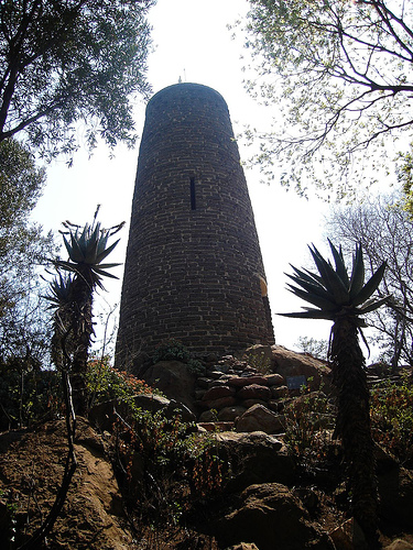
We reached Oppenheimer Tower complex which is set within parklike surroundings. The tower was built in 1955 from ash bricks which were the remains of shantytowns.

Oppenheimer tower
Figure: Oppenheimer Tower

The view from the tower provides a sense of the vastness of Soweto. From here looking south, there is a great view of the train-like housing architecture of Jabulani Hostels. Further in the south-west, the West Rand Administration Board (WRAB) Fresh Fruit Market is visible. The WRAB Fresh Fruit Market was set alight and destroyed on June 16 1976. We were reminded of the violence of that day’s events by Oupa Moloto recalling the gruesome sight of a headless boy lying on the ground with a cabbage under each arm.

View of Soweto
Figure: The vastness of Soweto from Oppenheimer Tower

Other landmarks visible from the tower include the 1976 memorial acre and the former home of Tsietsie Mashinini (see below), both of which are located close by in the suburb of Central Western Jabavu which surrounds the tower complex to the north and east. Still within the Oppenheimer gardens, we took a moment under the shadow cast by the Oppenheimer Tower where Mpafi Mpafi reminded us of the running battles between township residents and hostel dwellers which occurred in the park. He also pointed out that the gardens were a place of refuge for students who hid amongst the trees.

The Oppenheimer Tower is located adjacent to The Credo Mutwa Cultural Village. The village, also known as Khayalendaba, or "Place of Stories", has always been associated with story-telling, rituals and ceremonies, plays and other cultural activities. Its founder, Credo Mutwa is a Zulu Sangoma or traditional healer, a cultural historian and an award-winning nature conservationist in South Africa. Credo who is over 80 years old, is known worldwide as the Zulu Shaman. In 1976 students thought he was a collaborator and his house in Diepkloof was burnt down in the aftermath of June 16. Later most of the cultural village was destroyed too because of Credo Mutwa’s testimony in the state’s official enquiry into the student uprisings.

Credo Mutwa
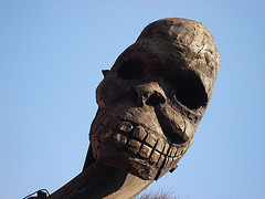
Figure: Mythological Sculpture at Credo Mutwa

From the Credo Mutwa Village and Oppenheimer Tower complex we headed back to Mputhi Street and parked across from Morris Isaacson High School at the 1976 Memorial Acre, which is in the process of development. Mpafi remarked that it was students from Morris Isaacson High School who were central to the planning of the student march on June 16. One such student, Tsietsie Mashinini, lived across the road from Morris Isaacson High School.

House Tsietsie Mashinini
Figure: The Home Of Tsietsie Mashinini

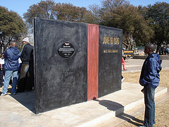
Today, the family of Tsietsie Mashinini is trying to purchase the former family home with a view to converting it into a family museum in honour of the fallen hero. The 1976 Memorial Acre contains a newly erected monument in Tsietsie’s honour. The monument was created as part of the Sunday Times Heritage Public Art programme. Its physical form resembles a giant book which symbolizes the crisis in education experienced in 1976. On the face of the book is the map of the route taken by the students from Morris Isaacson High School to Phefeni Junior Secondary in Orlando West, whilst the back cover of the ‘book’ is inscribed with a tribute to Tsietsie Mashinini.

Tsietsie Mashinini Monument (Sunday Times)
Figure: Monument to Tsietsie Mashinini

We continued up Mputhi Street past the killing site of Dr Melville Edelstein. Dr. Edelstein was one of two white officials beaten to death that day. A sociologist, Dr. Edelstein worked closely with many youth from Soweto. Earlier on the fateful morning, he greeted students as they past his house on Mputhi Street. However, once news of Hector Pieterson's death filtered through the ranks, happiness turned to anger and Dr. Edelstein was murdered for being a white man in the wrong place at the wrong time. Ironically, Dr Edelstein had warned that the hostility of township youth should be taken as a serious threat to peace in Soweto. In his thesis, written five years prior to the events of June 16, "What Young Africans Think” (1971), 73 percent of the youth interviewed listed inadequate political rights among major grievances.

Dr. M. Edelstein
Figure: Dr. Melvillle Edelstein's body was found here on Mputhi Street.

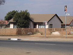
We briefly left the route in order to document two houses of historical significance. The first, belonging to Titi Mthenjana was known as ‘The Headquarters’ or HQ. This house was a safe haven for students who would sleep here in order to escape harassment by the police. The second house also a safe haven for students belongs to Mr Mbatha, a student mentor and advisor. Mr Mbatha’s home has changed considerably over time but Oupa Moloto still remembers how the home hosted important meetings of the SSRC.

Mshenguville
Figure: Mshenguville Informal Settlement

We returned to Mputhi Street and drove past Mshenguville Squatter camp, a former golf course. Further north on Mputhi Street, beyond the Roodeport intersection, the street name changes to Machaba Street. We turned right into Zulu Street and 200m ahead came to the site where Tsietsie Mashinini addressed crowds of students on the landmark bridge. The bridge is relatively unchanged since the 70s. Here Mashinini exhorted the students to remain calm and protest peacefully.

tsietsie landmark bridge
Figure: The Bridge where Tsietsie addressed students.

We continued towards Orlando West past the point where Machaba Street becomes Mahalafele Street, turned right into Phiri Street and left into Vilikazi Street. Our journey ended on Vilikazi Street at the intersection with Moema Street outside Phefeni Junior Secondary School. This is where students congregated on the morning of June 16 1976. Today this intersection has been memorialised by a monument marking the shooting site of Hector Pierterson. For many this is where the march ended as waiting police opened fire on protesting students.

Sources:

1. Moss, G. (1982): 'Crisis and Conflict: Soweto 1976-7', MA dissertation, University of the Witwatersrand.

Labels: , ,

The Vuwani Secondary School Route (Chiawelo)


This is the route taken by Reginah Msundiwa, a student at Vuwani Secondary School in Chiawelo. Msundiwa is a qualified nurse an currently works as a research assistant at Baragwnath Hospital.The importance of Msundiwa’s story is that she represents a participant who had no prior knowledge of the march and was surprised when she got to school on that fateful Wednesday morning. Msundiwa elaborates, “ I got to school in the morning and during the assembly students began to sing and we addressed by one of the student leaders - I don’t know his name. He said that today we are marching against Afrikaans. I was surprised, really, I was surprised!”

Vuwani Secondary School is located in Chiawelo in the far south western corner of Soweto. Students planned to march all the way to Orlando West and hoped to collect other students from neighbouring schools along the way. Their plan was to collect students from Sekano Ntoane before proceeding pass Morris Isaacson High School in Central Western Jabvu. However, the plan did not work out as intended as students from neighbouring schools left already.

Students from Vuwani Secondry School were the last group marching on 16 June 1976. They covered a fair distance, avoiding main roads as they ambelled towards Mputhi Street in White City. When the students got to Morris Isaacon High School the school grounds were empty. Msundiwa’s group was adressed by a student leader (not Tsietsie) who warned them about a looming police presence and called for a peaceful and calm protest.

The Vuwani group proceeded on Mputhi Street but a short while later they were met by police. By the time Msundiwa got to the corner of Mputhi and Roodeport Roads, news of the killing of Hector Pieterson and of the white socioogist Dr. Melville Edelstein reached her. Msundiwa remembers running for cover from police who began an assault on her group. The Vuwani group dispersed into the White City landscape, running into adjacent yards and houses in order to avoid gun fire.

Msundiwa’s march along with most students from Vuwani Secondary School ended here, outsdie Sizwe Stores about 10 Km away from Orlando West. A small group from her school continued through Mofolo Park in order to get to Orlando West. Their fate is still unknown.

Labels: , , , ,

Saturday, September 08, 2007

The Avalon Memorial Route

Date: 08 August 2006
Route Guide: Ali Hlongwane (Curator HPMM)
Documenter: Ismail Farouk

The Avalon Memorial Route is the symbolic funeral route taken in remembrance of all those who lost their lives during the Soweto Uprisings. Thirty years ago, in the aftermath of the violence, a mass burial was planned for the dead. An application to hold a mass burial was made to the Johannesburg Chief Magistrate - This application was denied. Further attempts to list all the dead were foiled by the police as the bereaved families were denied access to the bodies of the dead. It was Dr Motlana’s suggestion to hold a symbolic mass burial service to symbolise all the dead. The symbolic funeral service was conducted on Hector Pieterson at Regina Mundi Church (Mashabela 1987). Every year since then a special service is held at the church to commemorate the events of June 16 1976 followed by a procession to the Avalon Cemetery.

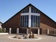
On the 08th of August 2006, Ali Hlongwane and I retraced the Avalon Memorial route from the Regina Mundi Church on the Old Potchefstroom Road. The Regina Mundi Church is a Roman Catholic Church and Bishop’s residence. The facility opened in 1962 and has been the scene for many mass gatherings of people over the years.

Regina Mundi Church

Figure: Regina Mundi Church

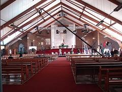
Regina Mundi Interior

Figure: Regina Mundi Church Interior

On this day, a very different kind of gathering was happening. CNN, the global media giant, was hosting a live public broadcast from the Regina Mundi Church. The broadcast was aimed at examining the state of the nation a decade after emerging from the isolation of apartheid.
After a brief inspection of the interior of the Regina Mundi Church, we drove down the Old Potchefstroom Road in a westerly direction. A short while later, we turned left into Sibasa Street in Chiawelo and traveled in a southerly direction.

SOMOHO

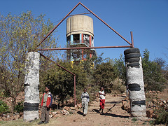
Figure: Soweto Mountain of Hope (SOMOHO)

We past the famous SOMOHO water tower on a little hill. SOMOHO stands for Soweto Mountain of Hope. The site is a community cultural initiative which transformed the barren, dangerous hill into a beautiful cultural centre.

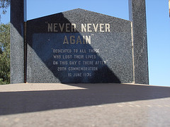
We continued south and soon we reached the entrance of the Avalon Cemetery. Avalon Cemetery is one of the largest cemeteries in South Africa and is the final resting place of many political and cultural activists. The cemetery is about 170ha in size and is managed by the City of Johannesburg’s City Parks division. At the entrance to the cemetery, a memorial with the words, “Never Never Again” inscribed on it pays tribute to those who lost their lives in the Soweto uprisings of 1976.

Never Never Again

Figure: Memorial to Fallen Heroes - Avalon Cemetery

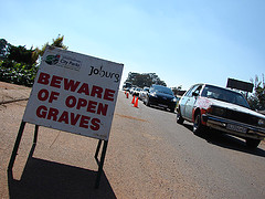
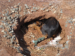
One of the many problems experienced at the cemetery include the digging up of graves by wild dogs. Some graves have been ‘fenced’ off using metal structures which resemble little beds in order to protect them from wild animals.

Beware of Open Graves

Figure: Beware of Open Graves

Dog in Grave

Figure: Dog in Grave

With more than 200 funerals occurring each weekend, Avalon Cemetery is facing severe pressure. The death rate is increasing by 10% per year. Cremation is not considered appropriate for most people so City Parks are encouraging families to consider the “second burial” option, where several members of a family are buried in the same grave. Compounding the problem is the Aids pandemic. With more than 6.5 million of the country's 47 million people infected with HIV, demand for space is increasing. Every weekend, convoys of buses carrying mourners bring the Old Potchefstroom Road to a standstill. This has resulted in special traffic marshals being deployed to deal with the traffic congestion every weekend.

"We Cannot Continue To Die Like This"
(An original video artwork by Babak Fakhamzadeh and Ismail Farouk)

Labels: , , , ,